Owning waterfront property sounds like a dream. You picture boats tied to a private dock, morning coffee on the porch, and a front-row view of the harbor. Yet, along with those views often come conflicts. Neighbors may question where a dock begins, where property ends, or who gets to use a shared path to the water. That’s when a boundary survey becomes more than just a technical document—it turns into your strongest piece of evidence.
Why waterfront disputes happen
Boston’s shoreline is tight and busy. Unlike wide suburban lots, waterfront parcels often sit side by side with little space in between. Add in seawalls, piers, public walkways, and easements, and suddenly the question of “who owns what” gets cloudy.
For example, one neighbor may claim that part of your dock crosses onto their parcel. Another may insist that a shared footpath is private, not public. And when you want to build a new seawall or expand a deck, the city may demand clear proof of your property limits. Without boundary survey, those arguments can drag on and even end up in court.
What a boundary survey does for you
A boundary survey gives you a legal map of your property. Licensed land surveyors use precise tools to locate your corners, measure your lot, and confirm property lines against deeds and records.
On the waterfront, this map doesn’t just outline land. It often includes mean high-water marks, dock alignments, and access easements. That information protects you in two ways:
- It confirms where your rights begin and end.
- It provides evidence if someone challenges your dock, deck, or shoreline access.
In short, a boundary survey turns opinions into facts.
Dock disputes: who controls the water’s edge?

One of the most common waterfront arguments involves docks. Boston’s harbors and inlets are full of piers, and many have been rebuilt or extended over the years. But not all of them sit neatly within one property’s limits.
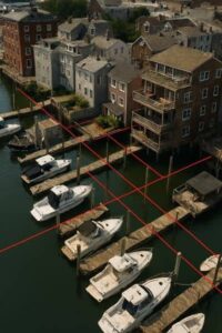
A neighbor may believe your dock overlaps theirs. The city may question whether your pier crosses into public waters. In these cases, a boundary survey with detailed measurements of shorelines and structures shows exactly where the legal limits fall.
When paired with historical records, it can even reveal if a dock was built in the wrong place decades ago. That proof can make the difference between keeping your investment or facing an order to remove it.
Easement disputes: who gets to pass through?
Another flashpoint involves easements. Many waterfront parcels come with access rights that allow others to cross your land. These easements may benefit neighbors, utilities, or even the public.
Confusion often rises because older easements were written in vague terms—“the right to access the water” without clear width, route, or limits. Over time, people interpret them differently.
A boundary survey can locate and mark easements on your property, showing where they exist and how they impact your land use. With this clarity, you can enforce limits if someone goes beyond their rights, or defend yourself if accused of blocking access.
How surveys help resolve conflicts before they escalate
Disputes about docks and easements can strain neighbor relationships and stall property improvements. The longer they linger, the costlier they get. A professional boundary survey provides neutral, third-party measurements that everyone can trust. Instead of arguing over opinions, you present certified data showing exactly where property lines, easements, and dock limits fall.
This evidence can:
- Help resolve disagreements in early conversations.
- Provide clear documentation to city agencies reviewing permits.
- Support your case if the conflict reaches court.
Many times, simply showing a stamped survey calms tensions. Neighbors see that a licensed professional—not just you—confirmed the boundaries, which makes discussions more cooperative and less confrontational.
Boston’s unique waterfront challenges
Boston brings extra wrinkles to waterfront surveying. Historic properties often have old deeds with vague descriptions. Tides shift the high-water mark, which affects property lines. And local agencies, from the Boston Conservation Commission to the Massachusetts DEP, keep a close eye on shoreline development.
Because of this, a simple DIY sketch won’t cut it. Working with a licensed boundary surveyor ensures your measurements are precise and recognized by the city. Their expertise helps prevent disputes with neighbors and keeps your project on track, giving you confidence that your waterfront improvements are built on solid, accurate boundaries.
Choosing the right surveyor
Not every surveyor handles waterfront parcels. You’ll want someone who understands:
- Tidal boundaries and shifting shorelines.
- Local easement patterns along harbors and rivers.
- How city and state agencies review dock permits.
When you hire a surveyor with this expertise, you get more than lines on a map—you get peace of mind. You know your property rights are protected, and you won’t be surprised by hidden conflicts.
Boundary survey: more than paperwork
It’s easy to see a boundary survey as just another item on a to-do list. But on Boston’s waterfront, it’s a shield. It protects your right to use a dock, confirms access routes, and helps you deal with neighbors or regulators fairly.
So if you’re planning a new project, buying a waterfront home, or facing a dispute, don’t wait until the conflict grows. A survey done early saves time, money, and stress.
Final thought
Waterfront living is rewarding, but it comes with extra layers of complexity. Docks, easements, and shoreline rules can create gray areas. A boundary survey clears the fog. With accurate measurements and legal proof, you can enjoy your property, respect your neighbors, and move projects forward without constant worry.
If you own or plan to buy waterfront land, make sure a surveyor is one of your first calls. It’s the simplest step to protect your investment and your peace of mind.


